Births
Book Store
Cemeteries
Census
Churches
Court Records
Deaths
Ethnic Interests
Family Connections
Research Guide
History
Land and Mapping
Libraries
Links
Lookups
Marriages
Military
Newspapers
Order Records
Queries
Researchers
Surname Register
Tax Records
Tips for Research
Towns
About This Site
Landowners Mapping Project
Landowners Surnames | Henry County Map | Homestead Act 1862
About the Project:
I wanted to do something to help researchers of ancestors which resided in Henry County Alabama. My answer was to do some mapping work that has helped me in locating affiliated families...and sometimes that elusive maiden name of female ancestors. I have found in my research that it is often helpful to understand not only our ancestors, but their neighbors and affiliated families that resided within their homestead area. These are sometimes the families that immigrated together to a new area and are often the families that our ancestor's children intermarried with. By studying the mapped area of your ancestors, I hope some valuable clues develop from the surrounding entities. Jeffery Palmer
How to Locate Your Ancestors Land in Henry County!
Alabama, like the rest of the Public Domain States, was subject to the Federal Township and Range System for identifying land. We are not going to discuss the how system brought us to Henry County. You can read more about it at: Legal Land Descriptions in Federal Township and Range System. To plot the land you need a land description from the General Land Office for original land patents or a record of sale from the County Court House. Print this Henry County Map for a ready reference which is marked with the Township and Range Lines. This map can be used to roughly plot your ancestor's land. Township and Range lines are 6 miles wide. The crossing of the two lines create boxes that are approximately 6 miles square. Each Township/Range box on the Henry County Map is numbered to indicate which Township and Range cross to create that square. (Example: 7N26E) Township 7 North and Range 26 East.
All Land Descriptions under this system read from the smallest division and go to the Largest, but to use them you have to read from the largest to the smallest or right to left. The following two descriptions are for land bought by Mathew Tolbert Allen on November 1, 1858 at the Land Office in Elba, Alabama.
1) NESW - 10 - 5-N - 29-E - St STEPHENS
2) NWSE - 10 - 5-N - 29-E - St STEPHENS
Reading from right to left, the first entry is "St. Stephen" which is the St. Stephens Meridian, which is a north-south line that all land in the southern half of Alabama is measured from. All land in Henry County will have St. Stephens in the description. The next part is 29E and is the Range line number (Vertical Line). 5N is the Township line designation (Horizontal line). So on our Henry County Map that you printed earlier, this land is in the square marked 5N29E.
| Each of the Township/Range boxes are further broken down into approximate 1 mile squares that are called sections. There are 36 sections in a Township/Range box. The numbering of these sections start in the top right of the Township/Range box and go to the left. The next line starts in the section box under the section 6 box and the numbering goes to the right and then continues in a zigzag pattern as shown in the illustration. Each of these numbered 1 mile square boxes are called a Section and contains 640 acres. Now we are ready for the next part of the Land description for Mathew's land which is a "10" and indicate that the land is in Section 10 of the Township/Range box 5N29E. | |
6 | 5 | 4 | 3 | 2 | 1 | | 7 | 8 | 9 |10|11|12| |18|17|16|15|14|13| |19|20|21|22|23|24| |30|29|28|27|26|25| |31|32|33|34|35|36| |
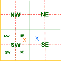
| Each Section box is divided into Quadrants and each Quadrant is
divided into four parcels creating sixteen 40 acre parcels of land. The quadrants are named
NW (northwest) for upper left, NE (northeast) for upper right, SW
(southwest) for lower left and SE (southeast) for lower right. Each Large Quadrant is divided
into four parts and are label as are the larger quadrants.
Now we will look at the last portion of the land description. The two descriptions are NESW and NWSE. The first will read: "The Northeast 1/4 of the Southwest 1/4". The 40 acre parcel marked with the orange X The second description reads "Northwest 1/4 of the Southeast 1/4". The 40 acre parcel marked with the blue X. |
 |
About the Map Pages Layout:
There will be a map page for each "Township/Range box" as indicated on the Henry County Alabama Map.
On each page will be links to the "Township/Ranges maps" North, South, East and West of the current map.
A Link to a graphic on the current page of each Section, displaying the Original Land Patent Owners and the date the patent was signed for each 40 acre parcel in each Section of the current "Township/Range Map." This does not mean the owner moved onto the land at that time. They may have homesteaded the land many years before even applying for the patent, and the patent may have taken a year or more before being issued. Or, they may have never homesteaded the land at all.
Lastly, until the project is COMPLETELY finished, some of the connections on each page to connecting pages will be inoperable. It is suggested that you connect to different sections of the mapping project through the Land Surname Index, which you can access here:
Maps and Land Records by Shirley McLellan and Arline McAlister
Graphics by James D. Allen and Valarie Adams

