Elmore County ALGenWeb
Click here to see Maps of Elmore County
Elmore County Pages
On Line Resources in Elmore County
A good place to start your first visit.
Look Ups in Elmore County
[if you can help please volunteer]
Elmore County History
[with maps and documents indexes]
Elmore County Cemeteries
A complete listing of the Cemeteries and contact information
Interactive Map of Surrounding Counties
(a map with links to other Counties)
In Print in Elmore County
books available Elmore County
Elmore County Links
to pages related to Elmore County
Elmore County Vital Records
where to look in Elmore County
Elmore County Former County
(Places once in another county.)
Elmore County Genealogical & Historical Societies
(Listings of Societies with links)
Elmore County Researchers
(Lists researchers by surname)
Beneath the Lakes
(Contains information communities, churches, cemeteries, or historic locations)
Elmore County Maps
(Listing of maps and links.)
Elmore County Libraries
(Lists local, state and regional libraries)
Afro-American Research
(Lists links and mailing list info)
Elmore County Reunions
(Info can be placed here if submitted)
Native American Research
(MUSCOGEE - A STUDY OF THE CREEK INDIANS
The Original Inhabitants of much of Alabama And Georgia)
Elmore County Military
(Contains items related to the military or wars)
Want to Help?
(Lists ways you can help with the website)
How to join the ALElmore list
(Lots of great info and help on the list)
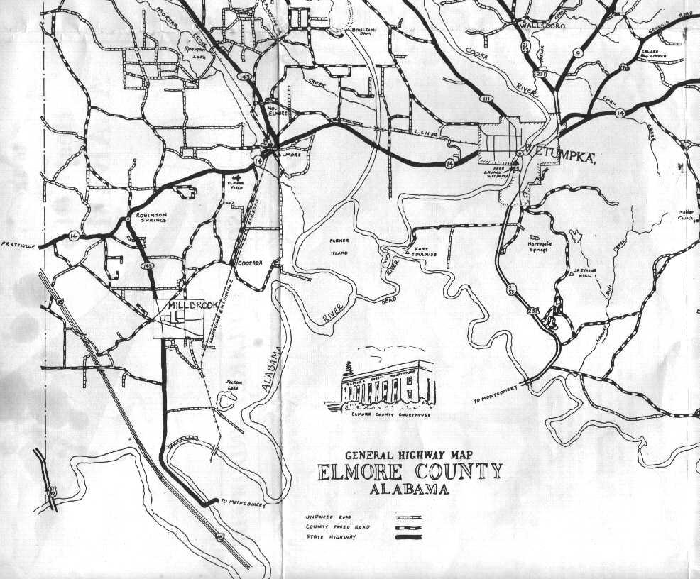
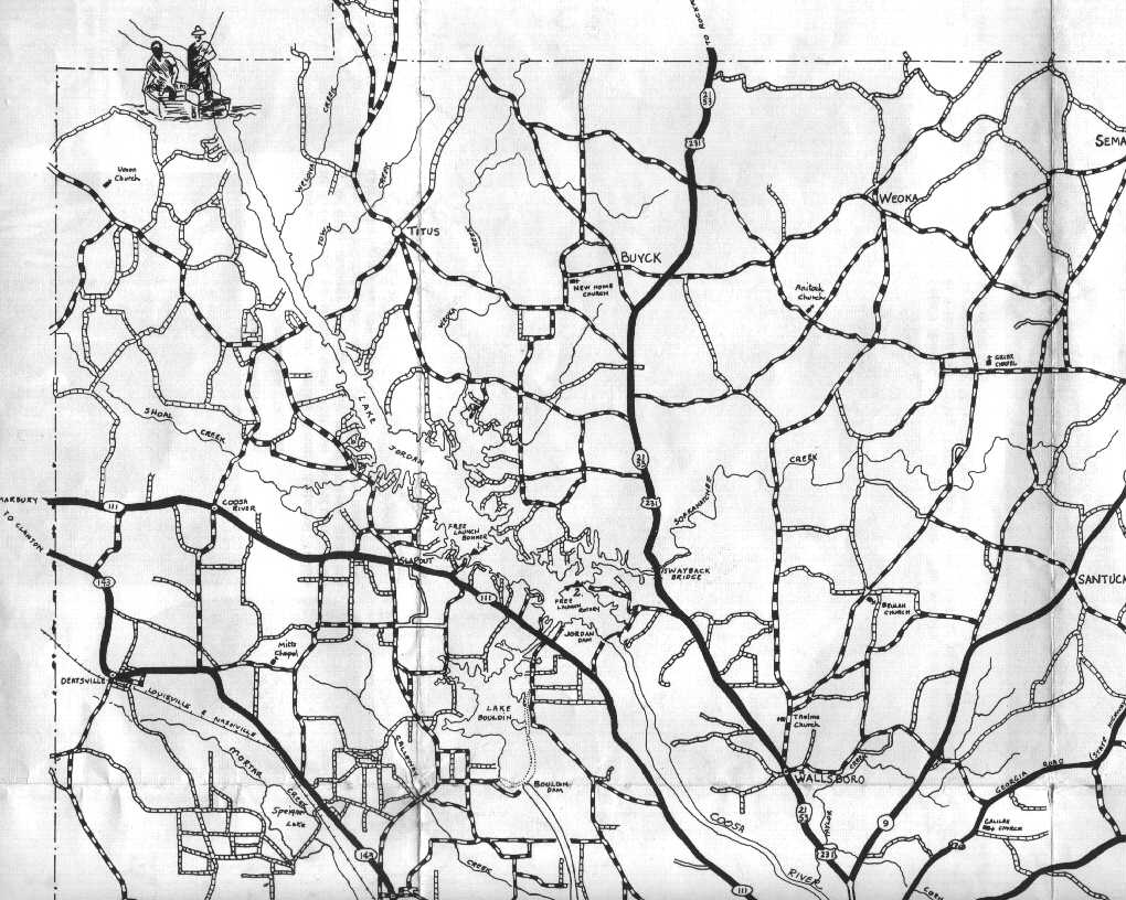
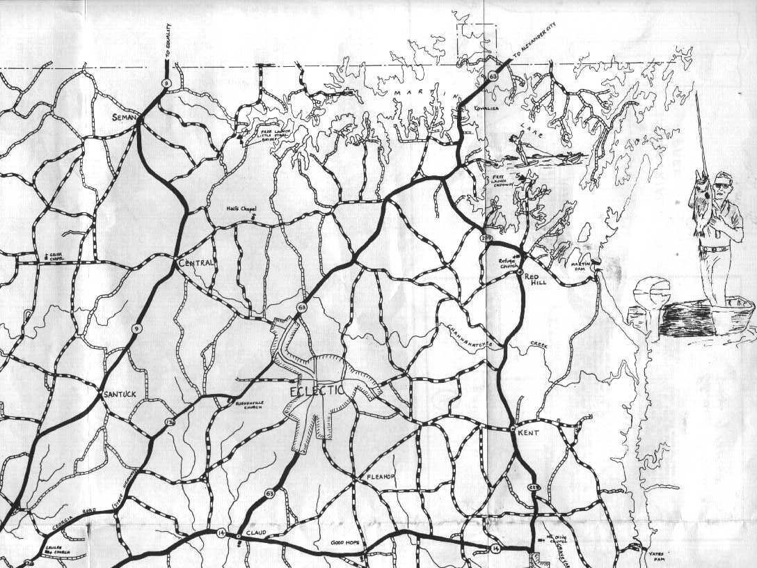
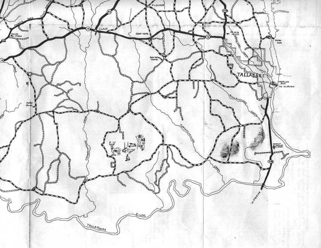
k. i. s. s. I try to keep it simple! |
|
|
Elmore County Maps
- Sources for printed maps can be found in the "In Print" section of this webpage.
- Maps from the Washington Co. AL USGenWeb page
- Alabama 1839 [122k] A portion of the large (493K)1839 map of AR, TN, w.NC, SC, GA, AL, MS, and LA, from Hargrett Collection, U. of GA. Click "back" to return here.
- Alabama in History [Maps at bottom of page].
- Elmore County AL
formed in 1866 from parts of Montgomery, Autauga, Coosa, and Tallapoosa counties.
AniMap note.
- Elmore Co. 1895 [27k] cropped from the 1.6mb AL map from the 1895 U.S. Atlas Project.
- Present-day Elmore Co. [35k] This is a quick-loading version of
the map provided under "History/Maps" on the "Location table/Adjacent counties" page. This map is remarkable
in that it shows Fleahop, not included in the GNIS list nor in AniMap's "SiteFinder"!
- 1972 Elmore County Highway Map
- Alabama county lines 1831, 1832, 1866 and 1875, courtesy of
Gold Bug and Art Lassagne.
- Custom maps of Elmore Co. using Tiger Map Server
There will likely be more of these. Virtually every location is converted from
minutes-degrees-seconds to decimal-degrees and manually entered. If you find error(s!) or wish
other locations added, tell me.
- Listing, for all 20 counties, showing GNIS/Tiger map data for all towns, locales, schools, cemeteries, churches and streams is found at East Central Alabama Locations.
- Elmore Co. GNIS locations on one listing . This is big [157k] and slow-loadiing (why GNIS didn't do it!). But it is
useful for having access to "all there is", 659 features, at one time.
-
B&W Line outline AL map [201k] from the University of Texas at Austin.
- Color Landform Atlas of the U.S. from the Applied Physics Laboratory at Johns Hopkins
University.
- County outline map of AL
from the US Census Bureau.
- Alabama Maps Index from the Geospatial and Statistical Data Center
University of Virginia Library • PO Box 400129 • Charlottesville VA 22904-41291 • phone: 434.982.2360 • fax: 434.924.1431.
Many Thanks to the Previous County Coordinator - John Robertson
ALGenWeb is part of the USGenWeb Project.
© 1998, 1999, 2000 John Robertson
© 2000, 2001-Present ALGenWeb Team
© 2000 - 2025 The Elmore County ALGenWeb Project - All Rights Reserved.
|
|